| Ninety years of dreaming
and planning The Point Pleasant Canal When the canal was opened in 1925 the upper Barnegat Bay was transformed from a stable fresh water area to a salt water bay with tides and currents. No environmental impact statement was needed. Timelines | Pt. Pleasant Historical Society | Pt. Pleasant History | Images | Sites | Books | Tidbits | End | Send Mail  The Point Pleasant Canal first connected Barnegat Bay with the Manasquan
River about three quarters of a century ago. That two mile ditch had
been a dream of local planners since the early part of the nineteenth
century and it became a nightmare shortly after its opening.
The Point Pleasant Canal first connected Barnegat Bay with the Manasquan
River about three quarters of a century ago. That two mile ditch had
been a dream of local planners since the early part of the nineteenth
century and it became a nightmare shortly after its opening.
In 1833, the New Jersey Assembly authorized the creation of the Manasquan River and Barnegat Bay Canal Company to connect the bay to the Manasquan River through what is now Twilight Lake in Bay Head and Lake of the Lilies, Little Silver Lake, and Lake Louise in Point Pleasant Beach. Nothing came of this plan or similar ones proposed periodically through 1911. In 1912, proponents shifted their interest to the site that was
eventually selected. The beachfront area had been developed to an extent
that the original route was impractical. A 1903 plan, for instance,
called for eight bridges and a railroad draw. Its cost was estimated at
$155,000 compared to the $5,000 estimate for the original proposal
seventy years before. With an initial $30,000 appropriation from the legislature, the canal was finally begun in 1916 with dredging through the Bay Head marshland. A half mile was dug before the United States entered World War I and construction was suspended. Progress resumed in 1918 after emergency defense funding was secured. For seven more years excavation proceeded at a snail's pace because the state would make only small appropriations each year and costs climbed. The stop-and-go nature of the funding resulted in new bidding and frequently changing contractors. The LeChard Dredging Company of Point Pleasant took over the project for a while. The original Rt. 88 bridge was constructed while the canal was still dry. The Lovelandtown bridge was built in 1929, several years after the opening. There are varying accounts of exactly when the canal became navigable in 1926, but a climatic moment came at 3:15 p.m. on December 15, 1925 when a scoop dredge lifted a shovel full of dirt and allowed the waters of the Manasquan River and Barnegat Bay to intermingle.
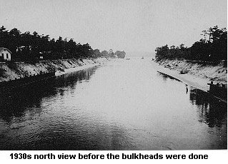
Problems and Controversies The Point Pleasant Canal has always been a source of controversy, problems, or ambivalent emotions. Citing the fact that the waterway is entirely within Point Pleasant Borough's boundaries, and wanting to be more closely identified with the canal, Point Pleasant officials in 1964 successfully petitioned Congress to change the name from the Bay Head — Manasquan Canal to the Point Pleasant Canal. But in the 1990's some town officials, wanting to show there was more there than just a ditch dividing the community in half, made an unsuccessful proposal to find a new slogan for Point Pleasant to replace "Home of the Canal." The first canal debate involved the nature of upper Barnegat Bay and the Metedeconk River, which would change from a fresh water to salt water environment if the waterway were dug. Many residents of that upper bay area opposed its building because the intrusion of salt water would (and eventually did) bring tides and currents to the still waters, destroying or diminishing bass, perch and pike fishing, and destroying cranberry bogs. Immediately after its opening to navigation in 1926, the strong currents that have plagued the canal ever since began causing serious problems. In less than six months its banks, which were not bulkheaded, had been eroded, creating shoaling and nearly closing it. The two bridges began to be undermined. The real disaster came as Manasquan Inlet began to shoal over and close several months later. Boaters blamed the diversion of river water down the canal. Efforts to keep the inlet open using high pressure hoses were losing battles. For most of the time through 1930 the inlet was closed. Steam shovels were finally brought in and jetties built. The inlet was reopened in February 1931. • The inlet reopening story But the inlet reopening returned tidal currents to the canal, bringing back the erosion, shoaling and bridge undermining problem. In 1935 Federal officials begin building wooden bulkheads to end the erosion, a task that took until 1947 to finish. Around 1960, the bulkheads themselves began to erode at their bases. To stabilize them and the aging bridges, the Army Corps of Engineers began dropping boulders into the canal. But this made some sections more shallow and, with the same amount of water rushing through, those sections developed extremely hazardous currents. One section by the Rt. 88 bridge became a series of rapids. The situation improved as both original bridges were replaced (Lovelandtown in 1972 and Rt. 88 in 1986), the wooden bulkhead was replaced with steel, and the rocks were removed.
— By Jerry Woolley and Jeff Heim
Timelines | Pt. Pleasant Historical Society | Pt. Pleasant History | Images | Sites | Books | Tidbits | Top | Send Mail |